Saugatuck Harbor 1919
2025.01.37
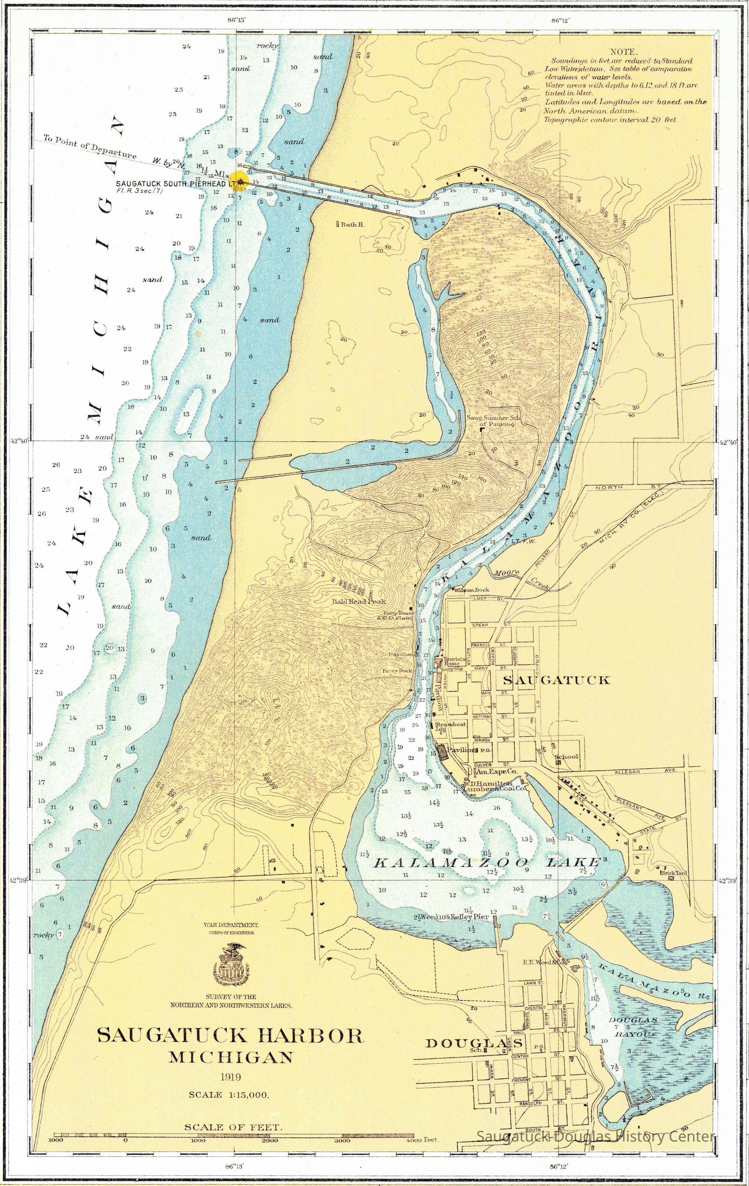
In addition to depth soundings and elevation, streets and some buildings, the map shows a single navigational light at the Saugatuck South Pierhead and a Steamboat landing along the river where Coral Gables is in 2025.
MapsNauticalTransportation: water
Winthers, Sally
2025.01
Found in Collection
Map emailed to S. Winthers by Chris Clark, 15 Aug. 2025
1:120000
1919
Filename: 76-6-1919 Title: LAKE MICHIGAN. SOUTH HAVEN TO BENONA, MICH. Type: Nautical Chart Author: Lake Survey Publication date: Year = 1919 , Month= 6 Edition number: 0 Geographic bounding box (latitude/longitude): POLYGON((-86.64225724127347 42.35419698972518,-85.67890062676851 42.354204007435094,-85.67893839862947 43.56141028389089,-86.64230024692948 43.56139455387735,-86.64225724127347 42.35419698972518)) State: MI
digital asset
Digital data in CatalogIt
Saugatuck Harbor Piers/Channel 1906-presentBird's Bath HouseOx-Bow/Summer School of ArtInterurban Railroad 1899-1927100 Lucy/William Johnston/Wilson's Marina/Docks/Coal Office/Iron Clad basket factory735 Park/S-D History Museum/Shorey Cottage/Pump HouseMount Baldhead Dune/ParkOld Chain Ferry Scows c1836-1947Mt. Baldhead Hotel 1933-1959/Tourists' Home 1901Big Pavilion 1909-1960Sergeant Marine/Saugatuck Lumber and Coal Co./W.D. Hamilton Lumber and Coal CompanySaugatuck Public School 1897-1950Saugatuck Brick and Tile Co. c1896-1919Goodrich Transit Co. warehouse/East Shore Pavilion Skating Rink/Brittian BoatyardOld Harbor/Channel piers pre-1906/Ox-Bow LagoonE.E. Weed & Co., 1880s-1927Douglas Union School 1866-Ox-Bow House/Old Library/Douglas Athletic Clubhouse/Methodist Episcopal ChurchRed Dock/Keewatin Dock/Tower Harbor Village/Eastland/Crawford Trans. Co. DockThe Boom/Dock Island/Griffin & Henry Lumber Dock
Constraints on Access and Use of the Data: The images are in public domain, so they can be used for any purpose (except for navigation), free of charge. All we ask is that you cite the website in some way. The preferred format for citation is as follows: Image from NOAA's Office of Coast Survey Historical Map & Chart Collection https://historicalcharts.noaa.gov
08/15/2025
08/15/2025